
At the entrance to the dusty town of el-Fashir in North Darfur, there is a sun-faded sign that reads “Desert Combat Department”. But despite the tribal conflict there, this is not an army unit but a municipal outfit with the Sisyphean task of holding back the immensity of the Sahara desert.
I was there as a foreign correspondent covering the war and attempting to understand the complexity of it all. One night, I was invited to a large dinner hosted by the governors of the three Darfurian provinces. During an interview, the governor of South Darfur told me about his youth growing up in the provincial capital of Nyala, where, as recently as 1992, the desert dunes stood a good 120 km to the west.
By the time of the interview in 2007, the dunes had invaded to a mere 5 km outside the city’s limits. That constituted an implacable eastward march of the Sahara desert of nearly 10 km a year.
So, desertification and environmental degradation, exacerbated by the decimation of Darfur’s trees by wood sellers, resulted in the compression of tribes already competing for scarce resources into ever smaller areas of viable pasturage.
Equitable access to waterholes and grazing land had, by ancient tradition, been controlled and balanced by delicate agreements between tribal chieftains. But socialist modernisation in the 1970s under the military regime of Colonel Gafaar Mohammed Nimeri deliberately eroded the authority of the chiefs.
The combination of vital wells swallowed up by desert sands and weakened tribal agreements had fuelled inter-tribal competition to the point where it resulted in regular massacres and atrocities, which deployments of United Nations and African Union forces were unable to prevent.
This sadly familiar contemporary thirstland scenario in which desertification drives conflict is a far cry, in fact by some 2,400 years, from the time when there had actually been a fish-filled Lake Darfur (sometimes called Lake Ptolemy) with a surface area of some 11,230 km² and a volume of 547 km³ at its maximum. Then, the Sahara, instead of being a 1,600 km-wide arid barrier, was mostly a lushly wooded, animal-rich grassland environment dotted with monsoon-fed freshwater inland seas and networked with rivers.
The natural fecundity at the height of the “North African Humid Period” as it is known, created human settlements that left some of what appear to be among the earliest depictions of people swimming—in Egyptian palaeolithic rock art from 10,000 years ago—and sowed the seeds for the cultures of what would later become the Nubian and Egyptian pyramid-building empires.
Climatologists believe the green Sahara phenomenon actually repeats in long cycles, and there is evidence of at least 230 previous occurrences cycling back to the first appearance of the Sahara seven to eight million years ago.
But while advancing that clock towards fecundity is a clear impossibility, there are significant modern regreening initiatives underway that might at least provide plentiful water to key developments in the 9.2-million km² Sahara, and transform huge swathes of the semi-arid Sahel fringes of the desert into silvicultural land—and much of the grassland savannah further south into arable farmland.
Beneath otherwise parched Darfur itself lies a huge, almost untapped, freshwater resource that underwrites the reliability of its remaining wells: the world’s biggest groundwater aquifer, with a total volume estimated at 150,000 km³, covering two-thirds of Egypt, a third each of Sudan and Libya, and a substantial part of Chad.
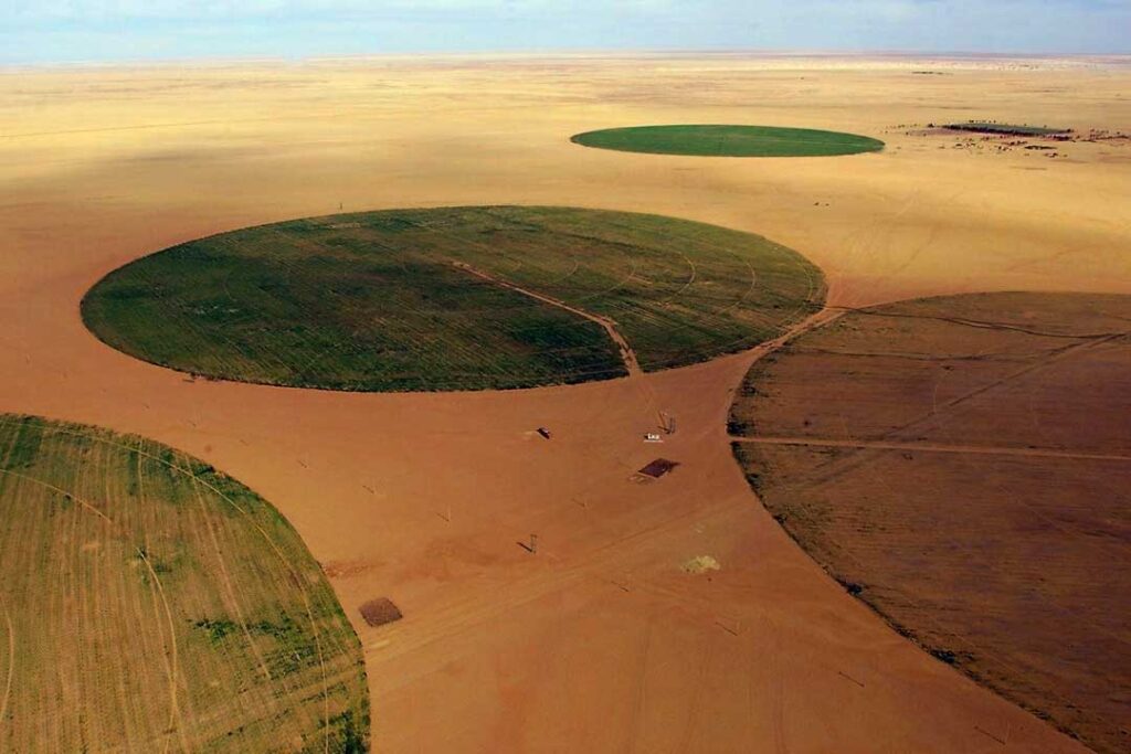
The world’s largest irrigation scheme already makes use of the aquifer, in which “fossil” water left over from the last great Ice Age as far back as 38,000 years ago is trapped in sandstone beneath the desert – in Libya’s Great Man-made River Project, involving some 1,300 wells in seven main well-fields deep in the Sahara.
The Nubian Sandstone Aquifer System (NSAS) was discovered in 1953 while drilling for oil. Construction on the project—the “world’s largest engineering venture”, according to the global specialist Water Technology journal—began in 1984, and the first water was delivered to the Libyan capital Tripoli in 1996. Despite disruptions caused by the ongoing Libyan civil war, the $25 billion system continues to supply some 2.4 million to 6.5 million cubic metres of water a year to Libya’s cities and farms (when completed, 155,000 ha should be irrigated).
But the aquifer’s subterranean complexity means it is hard to tell what such mass extraction means for multiple users of this finite resource, so in 2013, the four arid NSAS countries (Libya, Egypt, Chad and Sudan), with the technical assistance of the UN’s scientific body UNESCO and other multilateral bodies, signed an agreement on the equitable use of the aquifer.
As the announcement on the agreement stated, with “growing populations and decreasing water availability from other sources in the region, the aquifer is under mounting pressure. Removing water without a clear understanding of transboundary and other implications threatens water quality and has the potential to harm biodiversity and accelerate land degradation.”
Meanwhile, great progress has been made towards re-greening the semi-arid Sahel belt to the south of the Sahara. If the late Libyan leader Muammar Gaddafi was the visionary for the aquifer project, Burkinabé farmer Yacouba Sawadogo is his peer regarding the reforestation of the Sahel.
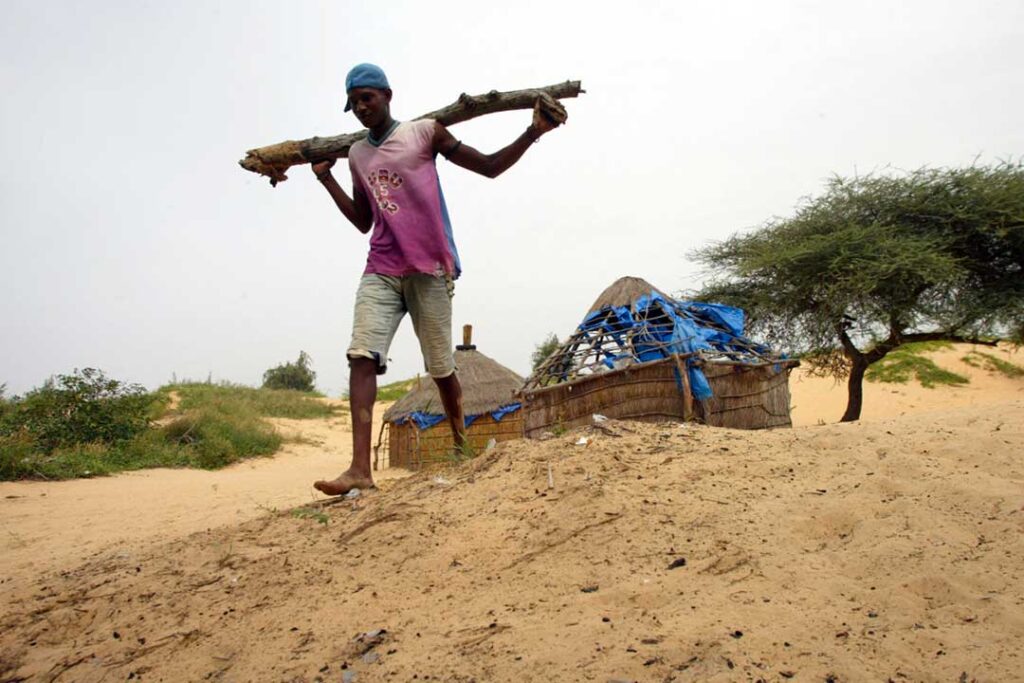
In 1972, the Sahel entered a 12-year period of severe drought, exacerbated by overgrazing, overpopulation, and poor land management, that eventually led to hundreds of thousands dying of famine as the groundwater table dropped by a metre, and formerly farmed slopes became heavily eroded and unfarmable.
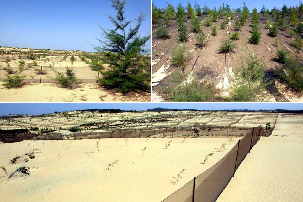
Sawadogo and his neighbour Mathieu Ouédraogo came up with a method of placing rows of stones, three stones wide, along the contours of the slopes to retain rain runoff, giving it a better chance to soak into the soil, as well as for nutrient-rich silt to accumulate and for crops to take root along the rows.
This cordons pirreaux practice was bolstered by an adaptation of traditional water-trap zaï or tassa holes. Dug into the soil about a metre apart between the stone lines, the holes were made larger than usual and filled with manure and compost, which not only provides crops with nutrients but also attracts termites who tunnel and thus break up hard, drought-compacted soil. Zaï/tassa holes increase the productivity of maize, sorghum, and millet crops by up to 500%, according to the International Food Research Institute.
Combined with agroforestry – the practice of interspersing crops with trees and shrubs (also farmed for wood, nuts, and fruit) to improve soil resilience and fertility, reduce water evaporation and runoff, widen biodiversity, provide year-round harvesting of different crops, enhance carbon sequestration, and increase crop yields – Sawadogo’s pilot project quickly established a remarkable 40-hectare forested farm near his home village.
His methods caught on across the Sahel, and former TIME magazine Africa correspondent Alex Perry wrote that by 2004, 300,000 hectares had been re-greened in Burkina Faso, five million in Niger, one million in Ethiopia, and 450,000 in Mali: “More than five million people were farming themselves out of starvation.”
The idea was spread further by the 2010 documentary on Sawadogo, The Man who Stopped the Desert, and in 2019 by a YouTube instructional video available in French, Arabic, English, Spanish, and Malagasy.
A 2004 study of the practice in Niger noted its excellent environmental and farming results but cautioned that it was labour-intensive and could provoke conflict as newly arable land impinged on pastoralists’ grazing rights. Yet a 2011 study said that the rise in annual crop yields increased farmland values by about €2,000/ha (then $1,800/ha).
The new fields and forests not only buttress food security, but have arguably also increased rainfall in the replanted regions, raised the water table, spread the number of trees by up to 50%, decreased temperature, and improved African community autonomy from foreign aid and central governments.
Still further south of the Sahel, the wooded grasslands of the savannah embrace 13.5 million km², or 400 million hectares, representing 60% of the world’s uncultivated arable land. In 2017, the African Development Bank (AfDB) initiated a project to sustainably transform some 16 million hectares, or about 4% of it, into farmland for maize, soybeans, and livestock, turning Africa into a net exporter of those products.
The continent currently imports about $35 billion a year on what it should be producing: 22 million metric tons of maize, two million metric tons of soybean, one million metric tons of broiler meat, and 10 million metric tons of milk product. Scale is part of the problem: large commercial agriculture is rare, with 80% of Africa’s farms (some 33 million) comprising less than two hectares apiece.
The model for the AfDB’s Technologies for African Agricultural Transformation for the Savannahs (TAAT-S) initiative is Brazil, where the tropical Cerrado grasslands were turned into a $54 billion food industry within two decades through, as the bank stated, “skilful development of production technologies for new crop and livestock varieties; innovative soil and crop management programmes adapted to the tropics; wide-scale dissemination of new agricultural technologies; low-interest loans, and ambitious rural development programmes.”
The project has since been launched in more than 30 countries, and by 2020 it was beginning to record several success stories. Yet the Brazilian model is deeply problematic, as The Guardian warned the same year, saying 283,000 km² of indigenous Cerrado bush had been cut down since 2001, causing rising temperatures, droughts, wildfires, lower rainfall, pesticide pollution, and erratic river behaviour, not to mention displacing indigenous people and endangering animal species.
“Africa faces a dilemma,” admitted the authors of last year’s Africa Agriculture Status Report: “If it is not able to raise yields sufficiently, it will need to convert much of its remaining forests and natural grasslands into farmland – with associated high costs to the continent’s environment, biodiversity, and the ecosystem services that they provide – and/or become much more dependent on the global market for its food supplies.”
The improvement of productivity and economies of scale on existing farmland was preferable, the report enjoined, while Sawadogo’s methods have been commended for relieving pressure to plough the savannah. But exceptional care needs to be taken with future policy decisions on how Africa’s thirst is to be slaked.

Michael Schmidt is a Johannesburg-based investigative journalist who has worked in 49 countries on six continents. His main focus areas as an Africa correspondent for leading mainstream journals are emerging and high-end technologies, political developments, conflict resolution and transitional justice, and on the continent’s maritime and littoral spaces.